- Discover
- Journey In Laponia Pt 1
Journey in Laponia Pt 1
-
Notes From The Field, Staloluokta.
What is there to say? How to describe this scene, looking out across a vast lake to the distant mountains of Norway? Is it only light that determines the dimensions of this arctic landscape? Why do I even ask such a question?
We have already walked for six days down through spectacular, mountainous Sarek National Park on the western side of Sweden and just above the arctic circle. It is a place that for me, like so much else that life prefaces with a long period of anticipation, has been full of mystery and intrigue. Someone taken by Tolkein's fantasies might liken that to what the Misty Mountains on his hand-drawn maps might hold for a reader only part way into the tale. For Sarek, nothing less than a mountainous jewel, is actually quite a compact area, just about sixty kilometres in diameter, but with its two other adjoining national parks (Padjelanta and Stora Sjofallets – Europe’s first) the whole comprises the important and large World Heritage Area of Laponia.
My imaginings of this place, of what it would be like, images assembled from scraps of internet material, could never match reality. Here, where the Sami herders say that their reindeer are really only owned by the wind, my prefabricated vision has proven to be completely inadequate. It has not been a matter of misleading information. I realise now that I built it only from a sense of adventure, using almost nothing of nature's infinite detail, the very things that completely capture the senses and dominate every active moment of a day on the ground in this place.
These distractions from the wider view, from the slow turning of the scenery at our steady progress on foot, are impossible to overlook. They come in the form of just a single specimen of the many summer wildflowers now in bloom, in the pattern on the surface of an ice-scratched rock, in the arc at the edge of a scalloped, slowly ablating patch of snow, in the shape and scattering of the glacial boulder debris, in the way the clumps of trees and bushes are arranged over the form of the land, in the subtle differences in colours green and shades grey, in the flight habits and sounds of the birdlife, in the changing sky and in the diverse tracks taken by water on its downhill journeys everywhere.
On entering Sarek we stepped into a network of ice-gouged valleys with precipitous sides. From as much as fifteen hundred metres above, towering peaks and hanging glaciers looked down on us. Yes, there are direct opportunities to ascend using a gentler side valley or a long, lower-gradient spur here and there, and they are tempting, but not without a rope, crampons and ice axe for security. For us first-time visitors it is enough to choose a simple route through this maze and be more than content to just look up in wonder.
Only the lower parts of the valleys, and mainly in the ones carrying all the water away to the south-east and eventually to the Baltic Sea, support forest. Mostly it is mountain birch. Otherwise the only other vegetation to really hinder travel, to get tangled up with, are the thickets of the three dwarf willow species on the lower slopes of mid-elevation valleys. The main issue with this waist-high scrub is not the impedance it places in front us but the swarms of mosquitoes it harbours.
I really don't want to blow the mosquito aspect of travelling in these arctic lands out of proportion but, without a stiff breeze to clear the skies, serious steps need to be taken to address it. Mosquitoes are a known arctic summer hazard and seen from a distance as remote as Australia, particularly through the eyes of someone who reacts badly to their bites, there is a risk that this fact might kill any idea of a journey there even before starting the research. That would be a mistake.
The locals all wear quite heavy, long, waxed cotton-polyester trousers, mostly dark olives and greys but enlivened by multiple coloured pockets and reinforcing patches. It seems there is no other choice. It is the Scandinavian look, an implied statement of their outdoor experience and preparedness. For us who come more from the Kiwi school of mountain fashion, long trousers are unnecessary weight if one applies the principle that clothing and equipment should, as far as possible serve multiple functions. In country where creek crossings are frequent, time-consuming and sometimes challenging long pants are also a nuisance. We ignore the funny looks and ill-informed comments and walk in our shorts and very often short sleeves as well. If we need lower leg coverage for warmth our indispensable woollen long johns are worn under our shorts. People sneak glances at you, as if you have dyed your hair to look like a parrot. The knitted longs are easily pulled up over the knees. Our overpants can then, at anytime, be worn over the top to cut wind chill, keep our lower bodies dry and provide a certain barrier to a mosquito proboscis.
So, those serious steps for us come in the form of the two repellents we are carrying. One is a roll-on that gives the impression of being gentle on the skin. I'm not sure about that. Anyway, mine has gone beyond any usefulness for such a test. The other, a thick, oily concoction, comes in a small green bottle with, if I remember correctly without rechecking now, a yellow triangular symbol with an import akin to those diamond shape Corrosive Agent 5.1 placards hung on tanker trucks. They both work, for a while, and you must remember not to wipe the sweat off your brow with the hand that was used to apply or spread them. What about head nets? We did bring them but they are too fine and dark, obscuring detail necessary to move confidently over rocks and judge depths in the soggy fens. And just to complete the picture, it would be reasonable to expect that the higher altitude terrain where plant life contracts to mosses and lichens might be mosquito-free, wouldn't it? It isn't. Is this where those insects caught on the occasional winds that we have experienced so far finish up?
Although it is summer and already mid-July now, streaks of snow and ice persist in every steep, mountainside gully. High above and out of sight over ridges, lakes and glacier melt also spill over in spectacular waterfalls adding to the weight of water cascading down from the gully snowmelt. Iceland comes to mind in this aspect of Sarek but this is not basalt. The peaks here have the jagged outline of gneisses not the layered structure of basalt, evidence of past, successive volcanic eruptions. Everywhere streams run down to the valley floor where they combine into torrents that quickly become too dangerous to wade across.
The sound of descending snowmelt is constant. The high-pitched, background chatter of water falling down gullies and running out over rounded river rocks carries long distances through windless valleys, but only along lines of sight, and one is never out of sight of such cascades. How difficult will the crossing be? Will a long detour be required to find a safe-enough point? Might there be a trustworthy snow bridge? Will boots need to be kept on, resulting in wet feet for the rest of the day?
We entered Sarek sixteen kilometres after crossing the large hydro-electricity storage lake to the north, using the early-afternoon summer boat service from Ritsem. This is a small settlement at the end of a three-hour bus trip from Gallivare, a mining town with regular rail and air services from Stockholm.
Not far into our walk and early on the second morning we arrived at an impressive suspension bridge. This is the crossing of the Vuajatadno river, a wide, raging torrent draining many hundreds of square kilometres of connected lakes in the country all the way west to the Norwegian border. From the bridge you can see far up the course of the river as it drops without pause from the distance. There are no quiet reaches. Where it narrows at the bridge into several thundering drops I applied my canoeist’s eye to the water. No, running this section would be madness, suicide in fact.
Over the next few hours, as we followed the track on the other side, I looked frequently across to the river. It was like nothing I had seen before. With the volume of water came a warning. Take this country seriously. But, at the same time, I also felt an invitation was being handed to us, to enter into a new journey of discovery and breathe some freshness back into our lives.
One thing we did not appreciate is that on the established tracks, the Kungsleden and Padjelantaleden, the Swedish Tourist Foundation (STF), and the BTF, the Badjelannda / Sami run equivalent in Padjelanta National Park, maintain what I will call lodges, spaced between fifteen and twenty kilometres apart, open in summer, overseen by voluntary wardens, and with excellent, heated bunk rooms, kitchen facilities, drying rooms and some supplies for sale. First come, first served, stylish and quite dear, even for members. The re-supply of gas bottles, unburnable rubbish removal and so on all happen in winter by over-snow vehicles when wardens must also send in their food and other supplies. When you add in the fact that you can take your dog into these areas (because dogs have been a part of the thousands-of-years-old cultural heritage of Lapland) this country is quite a different type of beast to the Australian national park.
It was not long into day two before we were off the Padjelantaleden and on our own, working up around the huge Ahkka massif with it’s two thousand metre summits, following the Sjnjuvtjudisjahka (river) towards impressive Nijak, the sharp peak overlooking the northern outlet of the Ruohtes valley, the Ruohtesvagge. Yes, the nomenclature is challenging! The next day we ascended into Ruohtesvagge, up to the saddle where it turns over to the south-draining Rapavagge and made our camp just past the watershed.
On the morning of our third day, also our third with cloudless skies and what felt like tropical heat when on the go, we were sitting on rocks by our tent, spooning in the morning's muesli and sipping our tea when the first groups of what must have eventually numbered five thousand reindeer, including maybe a thousand new-borns, wandered up valley past us. We sat for more than an hour, delaying our pack-up and start to the day's walking to just savour this wonderful spectacle. Later on, an hour so down the valley, we looked back to see that groups of them had decided the going was just too darn hot and found snow patches for a morning lie-down! When one is fortunate to witness this sort of thing in nature, increasingly rare expressions of her fecundity, there is only one thing to say. It is simply great to be alive.
Sarek has no huts except some ‘renvaktarstugas’ - small, locked cabins belonging to the reindeer herding community on whose traditional tract of land they lie. You need to look closely at the map to see them marked there. There are also some reindeer fences. These keep the animals herded by one Sami community from straying up side valleys and mixing with the neighbour’s mob across the range. And, unlike the established trails, in Sarek there are no long boardwalk sections to carry the traveler across the saturated fens, and no short, wooden bridges over small creeks to help with the traffic flow.
There is just one bridge in Sarek right at a critical valley crossroads in the park. This is a place called Skarja. Without it our journey would be almost impossible unless we made a serious, carefully planned river crossing. This would require a swim with packs making use of the current streamlines on a wide, shallow bend in the river, one with a suitable landing somewhere downstream. Then there is that other problem, water temperature.
Otherwise, choosing the right side of a valley while you are still amongst the headwaters, according to where you want to go next is essential as you head down from the saddle at the top.
We spent three more days travelling down the Rahpajahka, climbing to an exquisite lakeside high camp a kilometre or so before a significant col. This col overlooks the first reaches of the lower valley where the unusual combination of braided water course and backwater wetland system in the Rapadalen begins.
Then we backtracked a long day, returning to the bridge at Skaja. From there we turned west for two days, along Alggavagge and then under the southern slopes of Alatjahkka into Padjelanta, the neighbouring national park where we are now.
This high-valley exit route from Sarek took us through more beautiful scenery, over large snowfields, around small lakes still partially ice-covered and larger ones, ice-free. Everywhere there is birdlife, species we will positively identify from my photos, finding their English names later. This will also be so for the plants, the flowers in particular - although we already have a number under control.
One thing about the birdlife is that you suddenly realise, when you pass a chick sitting helplessly on the open ground, that the many ground-dwelling species in this treeless landscape lead a very precarious family life. One evening we watched an eagle being harried by two long-tailed jaegers, then to see what only can have been a chick float slowly back to ground, released from the distracted poacher’s talons.
Sarek is also reputed to have bears, lynx and wolverines but the chance of a sighting of any of these is minimal. They mostly inhabit the lower valleys. We often saw moose droppings but no moose. Talking with an experienced young woman we met on the go, we were told that the arctic fox population in Sweden is in serious decline. The main reason is the likewise declining lemming population which comes and goes in seven year cycles and on which the foxes heavily depend as a food source to support their breeding times. Ecological changes wrought by increasing temperatures are also playing a part in these declines.
So, here we are now, out in Padjelanta / Badjelannda. We are hemmed in by a maze of lakes, moraine ridges, small streams, rivers and rounded peaks. It is a change from precipitous Sarek but no less engaging.
This is day nine and we are at our mid-journey helicopter food drop at Staloluokta, a drop we arranged at Ritsem. We have chosen to have a rest day, sort out our food and look around.
Peta spent over a month back at home making and then drying all our evening meals ahead of our travels. It is a lot of work – up to four days in the drier for many - but once a home-dried meal enters the backpacking experience an off-the-shelf, pre-packaged freeze-dried one seems like the rubbish that its packaging most certainly is.
There is a small Sami kiosk here amongst this collection of Sami summer dwellings, selling goodies to weary hikers who will pay dearly for a can of beer or a bag of chips, as well as more essential items. I held myself back, to the deliciously smoke-dried reindeer meat and also asked if it would be possible to recharge the two used camera batteries that I am carrying. All places have small solar systems charging car batteries to connect to the internet through the community wifi and satellite system. Yes, even out here. And every dwelling seems to own an aluminium run-about boat with an outboard motor to catch, amongst other species, the brown trout and arctic char in the lake. These are tethered to bushes along the beach shoreline.
We have more or less proved to ourselves that going nine days completely self-contained with dried food, the lightest possible clothing and equipment for these conditions (and a daily dose of anti-inflammatories) is about the physical load-carrying limit of our bodies these days. Fortunately, there is no shortage of water here. It is everywhere, as I think I have made clear, it is all immediately drinkable and so we need carry none. The liquid fuel for our stove is weight enough.
Staloluokta is on the shores of Virihaure, one of two vast, connected lakes dominating this high country bordering and continuing into Norway. It is about the mid-point of the Padjelantaleden. Demand is such that it is serviced several times a day by helicopter flights from Ritsem in the north and Kvikkjokk in the south. We had no idea. Hikers with less time than us fly in and walk one way or the other.
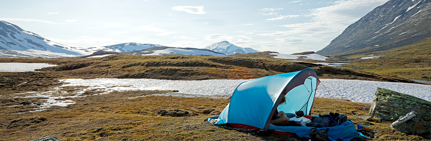
Our tent is pitched with a few others on the lake shore and our view is to the west. It is evening and here, just above the arctic circle, the sun is swooping down low. It will return to rise in the east tomorrowmorning, perhaps about two am, by slinking along, just below the northern horizon. Needless to say it is light, very light, twenty four hours a day. On heavily overcast days a watch is essential to keep track of time. After more than a week of sleeping in the twenty-four-hour light, I have noticed something very interesting about my eyes, something I have never seen before. Just after closing my eyelids in preparation for sleep a black screen descends to block the light still penetrating the lids, exactly like a blind being pulled down. I have checked again and again. It is real and must be a learned neurological blackout.
The more gently inclined hillsides out here in Padjelanta are also still plastered with snow patches, random handiwork of past snowstorms at first sight but obviously the deepest remains of winter's white smoothing out of the land's creases and hollows. On this cloudy evening the landscape is bright, bright in spite of the clouds, in spite of the dark greens and greys of the stunted arctic plants and rock surfaces of the lower slopes.
As I look out across the lake to the distant mountains it is as if I am looking into a vast, flattened corridor sandwiched between the lake surface and the low cloud base, one which clips the summits of the surrounding hills. The cold air clarity is perfect but there is something else, an uncanny brightness and, with it, a telephoto effect. A mountain far more distant, well off into Norway, appears as if just behind ones that are only a little beyond the lake.
The underside of the clouds stretching into the distance, in fact entire banks of them glow brightly. The sky in the extreme distance between the peaks, rather than fading to some dusty purple, is iridescent, with an orange-pink hue. Can it be that these three forms of water in the scene before me, the clouds, the lake and the snowfields are making triple-use of the sunlight? It seems so. The evening light enters obliquely through gaps in the cloud cover and becomes trapped between earth and sky. It ricochets back and forth giving a life and vibrancy to the scene otherwise impossible. It can only easily escape horizontally and one way is towards my eye.
Yesterday evening, camped high overlooking the icy lake Alatjavrre that we had spent half the day working along, I saw the same brightness despite having my back to the sun. An addition in that scene was a wonderful, isolated bank of mist condensed over the lake ice from the damp air of a weather change that saw us in the tent by mid-afternoon. It hovered there, a shimmering cloud of fog some tens of metres above the lake surface. Beautiful.
Take away the clouds, certainly, or take away the snow or the lake and it all goes flat. The closest we come to this arctic incandescence at home is a winter sunset over the ocean. Otherwise our brownish land just soaks up the light.
On cloudless days, and in Sarek we had five in a row, the appearance of the landscape was less mysterious. In the clear, unusually hot conditions then, there were no tricks of luminescence, no tightly-packed, receding layers of light, each as bright as the other to wreck havoc on my perception of distance. What we saw was exactly what we had to contend with. Yet, the scale of the valleys was still deceptive. Himalayan distances don't translate to this arctic mountain complex, even if the vertical forms of the mountains are similar. Here it takes just hours, not days to move beyond the view up one side valley and onto the next.
And so we go. Tomorrowwe will head south, up over high ground, threading our way between small lakes and hillocks, following the Padjelanta trail with all its trappings for a few days (but always finding a remote corner somewhere off the track to pitch our tent), before swinging west again into far less travelled country. We expect to take eight or nine days in all to finally reach the Norwegian border and descend to Sulitjelma where this absolutely wonderful journey on foot will end.